
HOW DOES VISTAMAP DO IT?
|
- VECTOR GRAPHICS - FLEXIBLE FILE FORMATS - COMPLETE UPDATING SERVICES - ARCHIVING - SUMMER CONVERSION |
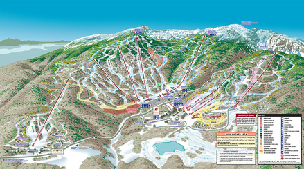
Creating an accurate and detailed wayfinding maps for ski resorts, amusement parks, zoos and other leisure activity venues can be a daunting task. Providing clear and concise information while presenting a colorful rendering is a valuable tool in enhancing the guest experience.
Gary Milliken, creator of VistaMap will visit the facility to gather all required reference, if necessary. While the client is asked to provide any existing information, old maps, aerial photographs, site plans, topographic maps, etc., VistaMap makes every effort to reduce the responsibility of the client to provide information. VistaMap will take ground level photographs, make rough sketches and schematics on site and take detailed notes to create the final art.
Rough sketches and various proofing materials are supplied to the client on a routine basis throughout the creation process, this assures that the image and information build in a progressive fashion towards a final map that meets or exceeds the clients expectations.
“I will also visit the resort, ski the entire mountain, familiarize myself with the terrain and take my own photos. However, no one knows the mountain like those who run it and their input is vital throughout the entire process.” - Gary Milliken / WSTI article